| Photo |
|
 |
| Marker # |
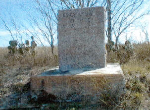
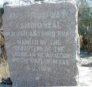
100 |
101 |
| County |
La Salle |
La Salle |
V. N. Zivley's Field Notes
(abstracted) |
Past Palo Blanco Creek, Deep Gulch and Los Esperansos
Creek. |
Across the Rio Frio -- South of Lawhon Crossing where
Gardendale Road turns right. (West, ed. note) |
Highway
Intersection |
|
On the South fence line of St. Hwy. 97 -- 3.15 miles West
of the McMullen/La Salle County Line. |
| City |
|
|
Additional
Description |
|
0.15 mile West of Old Fowlerton Road. |
Other
Comments |
This Marker has not been located. |
The Marker has been moved. |
Rededication
Ceremony |
There are no DAR Chapters in La Salle
County. That, coupled with distance, make it impossible to consider a
rededication ceremony. |
There are no DAR Chapters in La Salle
County. That, coupled with distance, make it impossible to consider a
rededication ceremony. |
Other
Historic
Marker |
|
|
GPS
Coordinates |
|
28°27.79
-98°48.98 |
| St. Hwy. 97 followed the original Kings
Highway for several miles in La Salle County and then veered off for
several miles. Judge J. W. Martin, County Judge (1951-1969) in the 1950's, wanting to
protect the Markers and preserve them for all to see, had #'s 101, 102,
108 and 109 moved to line the highway right-of-way into the town of Cotulla. |

| Photo |
 |
 |
| Marker # |
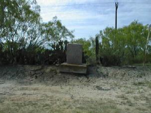
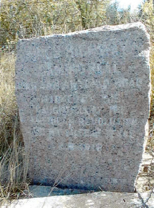
102 |
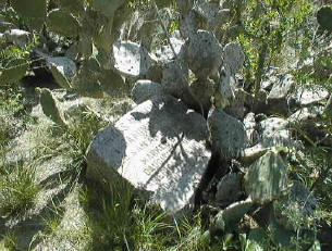
108 |
| County |
La Salle |
La Salle |
V. N. Zivley's Field Notes
(abstracted) |
Past Jakney Creek and South of Cibolo Creek. |
South of the S. A. U. & G. R. R. lines -- on the San Antonio
to Laredo Road. |
Highway
Intersection |
On the South fence line of St. Hwy. 97 -- 7.4 miles West
of the Mc Mullen/La Salle County line. |
0.15 mile West of Old Fowlerton Road. |
| City |
|
|
Additional
Description |
|
East of gas pipeline. |
Other
Comments |
This Marker has been moved. |
This Marker is broken. It is difficult to see in the
cactus. It has been moved. It was broken after
being moved. |
Rededication
Ceremony |
There are no DAR Chapters in La Salle
County. That, coupled with distance, make it impossible to consider a
rededication ceremony. |
There are no DAR Chapters in La Salle
County. That, coupled with distance, make it impossible to consider a
rededication ceremony. |
Other
Historic
Marker |
|
|
GPS
Coordinates |
28°
26.19
-98°2.75 |
28° 26.59
-98°55.91 |
| NOTE: There is a break in the numbering
here. Mr. Zivley stopped numbering with #102, went to the Rio Grande and
started with #128. When he returned to Marker #102, he had only put in 20
markers (128-108). Therefore, there are no markers numbered 103-107. This
information is taken from Mr. Zivley's field notes in the collection of
the Center For American History (formerly Barker History Center)
at the University of Texas in Austin. The viewer is invited to read the
explanation in full on the History page
of this website. |
| Photo |
 |
 |
| Marker # |
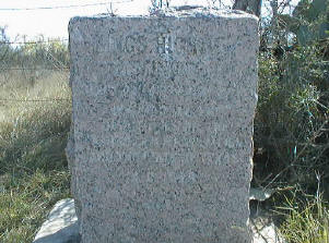
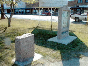
109 |
110 |
| County |
La Salle |
La Salle |
V. N. Zivley's Field Notes
(abstracted) |
WSW of post #108. |
|
Highway
Intersection |
On the South fence line of St. Hwy. 97 -- 216' South of
the intersection of St. Hwy. 97 with St. Hwy. 469. |
South fence line of St. Hwy. 97. |
| City |
Los Angeles |
|
Additional
Description |
15.1 miles West of the Mc Mullen/La Salle County line
facing North. |
21.8 miles West of the Mc Mullen/La Salle County line near
the crest of hill facing North. |
Other
Comments |
This Marker has been moved. |
This Marker is badly weathered and may have been moved but
not far from the original location. |
Rededication
Ceremony |
There are no DAR Chapters in La Salle
County. That, coupled with distance, make it impossible to consider a
rededication ceremony. |
There are no DAR Chapters in La Salle
County. That, coupled with distance, make it impossible to consider a
rededication ceremony. |
Other
Historic
Marker |
|
|
GPS
Coordinates |
28°27.95
-99°00.05 |
28°27.89
-99°06.60 |
| Photo |
 |
 |
| Marker # |
111 |
112 |
| County |
La Salle |
La Salle |
V. N. Zivley's Field Notes
(abstracted) |
|
On the North bank of the Nueces River. |
Highway
Intersection |
On the South fence line of St. Hwy. 97 -- on a bend in the
road -- 3.9 miles East of the intersection of St. Hwy. 97 with the R. R. |
On the East side of St. Hwy. 97 |
| City |
|
Cotulla |
Additional
Description |
4.1 miles West of Marker #110 facing North. |
Between the R.R. and Front Street in Cotulla city park
facing West. |
Other
Comments |
This Marker is badly weathered. |
This Marker was moved approximately a mile when this
information center was installed. |
Rededication
Ceremony |
|
|
Other
Historic
Marker |
There are no DAR Chapters in La Salle
County. That, coupled with distance, make it impossible to consider a
rededication ceremony. |
There are no DAR Chapters in La Salle
County. That, coupled with distance, make it impossible to consider a
rededication ceremony. |
GPS
Coordinates |
28°27.06
-99°10.27 |
28°26.22
-99°14.03 |
| Photo |
|
|
| Marker # |
113 |
114 |
| County |
La Salle |
La Salle |
V. N. Zivley's Field Notes
(abstracted) |
West of post #112 -- past Lagoon and Marsh. |
East of La Cochina Hill and Ranch owned by J. G. Childers. |
Highway
Intersection |
THIS MARKER IS ON PRIVATE
PROPERTY. |
THIS MARKER IS ON PRIVATE
PROPERTY. |
| City |
|
|
Additional
Description |
|
|
Other
Comments |
This Marker has not been located. |
This Marker has not been located. |
Rededication
Ceremony |
There are no DAR Chapters in La Salle
County. That, coupled with distance and this Marker being located on a
working ranch, no rededication ceremony is planned. |
There are no DAR Chapters in La Salle
County. That, coupled with distance and this Marker being located on a
working ranch, no rededication ceremony is planned. |
Other
Historic
Marker |
|
|
GPS
Coordinates |
|
|
Next County is
Dimmit.
Previous County is Frio. |
|
|