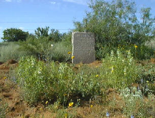
| Photo |
 |
 |
| Marker # |
115 |
116 |
| County |
Dimmit |
Dimmit |
V. N. Zivley's Field Notes
(abstracted) |
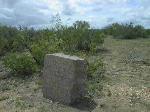
On the La Salle/Dimmit County line. |
West of the Pools of Romance. |
Highway
Intersection |
South fence line of St. Hwy. 133.
This
Marker has been moved from the original location. |
On the South fence line of St. Hwy. 133.
This
Marker has been moved from the original location. |
| City |
|
|
Additional
Description |
125' West of the Dimmit/La Salle County line facing
Northeast. |
4.4 miles West of the Dimmit/La Salle County line and 70'
East of the Piloncillo Ranch Road. |
Other
Comments |
|
|
Rededication
Ceremony |
There are no DAR Chapters in Dimmit County.
That, coupled with distance, make it impossible to consider a
rededication ceremony. |
There are no DAR Chapters in Dimmit County.
That, coupled with distance, make it impossible to consider a
rededication ceremony. |
Other
Historic
Marker |
|
|
GPS
Coordinates |
28°17.68
-99°23.70 |
28°78.70
-99°27.97 |

| Photo |
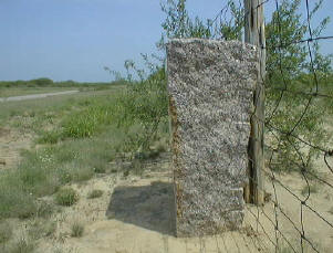 |
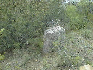
This photo shows the original location. |
| Marker # |
117 |
118 |
| County |
Dimmit |
Dimmit |
V. N. Zivley's Field Notes
(abstracted) |
West of Lomo Alto on San Miguel Lake. |
West of Post 117 -- past Loma Blanco Catarina Ranch owned
by Mrs. Anna S. Taft -- SW of the town of Catarina. |
Highway
Intersection |
South fence line of St. Hwy. 133.
This
Marker has been moved from the original location. |
The original location was on the Merle Burns ranch.
It has been moved to Catarina. |
| City |
|
Near Catarina was the original location. It
is now in Catarina. |
Additional
Description |
3 miles East of the intersection of St. Hwy. 133 and St.
Hwy. 83 facing North. |
This Marker was on private property. It is
now in downtown Catarina on St. Hwy 83. |
Other
Comments |
|
This Marker faced East when it was on the
Burns ranch. |
Rededication
Ceremony |
There are no DAR Chapters in Dimmit County.
That, coupled with distance, make it impossible to consider a
rededication ceremony. |
There are no DAR Chapters in Dimmit County.
Because of distance/time involved, no rededication ceremony is planned.
When the rededication ceremonies were held this Marker's location was on a working
ranch. |
Other
Historic
Marker |
|
|
GPS
Coordinates |
28°19.95
-99°33.88 |
|
| Photo |
 |
|
| Marker # |
119 |
120 |
| County |
Dimmit |
Dimmit |
V. N. Zivley's Field Notes
(abstracted) |
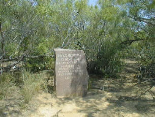
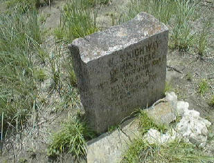
Catarina pasture -- The Kings Highway has been nearly
obliterated by a new road -- a very broad right of way has been cleared of
brush and prickley pear and the road-bed is graded 60 ft wide. --
Occasionally the old road can be seen first on one side and then the other
of the recent grade. |
WSW of Catarina Creek |
Highway
Intersection |
On the San Ysidro Ranch about 0.7 mile East of the front
gate facing West. |
On the Brisco Ranch. |
| City |
|
|
Additional
Description |
The ranch owner moved it about 300 yards from the original
location. |
|
Other
Comments |
THIS MARKER IS ON PRIVATE
PROPERTY. |
THIS MARKER IS ON PRIVATE
PROPERTY.
It has not yet been photographed. |
Rededication
Ceremony |
There are no DAR Chapters in Dimmit County.
That, coupled with distance and this Marker being located on a working
ranch, no rededication ceremony is planned.. |
There are no DAR Chapters in Dimmit County.
That, coupled with distance and this Marker being located on a working
ranch, no rededication ceremony is planned.. |
Other
Historic
Marker |
|
|
GPS
Coordinates |
28°19.18
-99°42.15 |
|
| Photo |
 |
 |
| Marker # |
121 |
122 |
| County |
Dimmit |
Dimmit |
V. N. Zivley's Field Notes
(abstracted) |
|
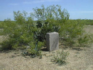
West of San Lorenza Creek. |
Highway
Intersection |
On the Faith Ranch. |
On the Faith Ranch. |
| City |
|
|
Additional
Description |
East-southeast of the entrance on top of a ridge
overlooking the Brisco Ranch facing North. |
Southeast of the entrance facing South. |
Other
Comments |
THIS MARKER IS ON PRIVATE
PROPERTY. |
THIS MARKER IS ON PRIVATE
PROPERTY. |
Rededication
Ceremony |
There are no DAR Chapters in Dimmit County.
That, coupled with distance and this Marker being located on a working
ranch, no rededication ceremony is planned.. |
There are no DAR Chapters in Dimmit County.
That, coupled with distance and this Marker being located on a working
ranch, no rededication ceremony is planned.. |
Other
Historic
Marker |
|
|
GPS
Coordinates |
28°15.623
-99°55.313 |
28°15.417
-99°57.760 |
| Photo |
 |
 |
| Marker # |
123 |
124 |
| County |
Dimmit |
Dimmit |
V. N. Zivley's Field Notes
(abstracted) |
|
Near San Pedro Spring. |
Highway
Intersection |
On the Faith Ranch. |
On the San Pedro Ranch. |
| City |
|
|
Additional
Description |
Along the main road South of the entrance at the base of a
windmill facing North |
At the San Pedro Creek crossing below the ranch
headquarters and East of the springs. Wagon wheel ruts are visible in the
rock approaching the Creek. |
Other
Comments |
THIS MARKER IS ON PRIVATE
PROPERTY. |
THIS MARKER IS ON PRIVATE
PROPERTY. |
Rededication
Ceremony |
There are no DAR Chapters in Dimmit County.
That, coupled with distance and this Marker being located on a working
ranch, no rededication ceremony is planned.. |
There are no DAR Chapters in Dimmit County.
That, coupled with distance and this Marker being located on a working
ranch, no rededication ceremony is planned.. |
Other
Historic
Marker |
|
|
GPS
Coordinates |
28°16.200
-100°01 .422 |
28° 16.362
-100°04.365 |
| Photo |
|
|
| Marker # |
125 |
|
| County |
Dimmit |
|
V. N. Zivley's Field Notes
(abstracted) |
On the Dimmit/Maverick County line and San
Ambrosia Creek. |
|
Highway
Intersection |
On the San Pedro Ranch. |
|
| City |
|
|
Additional
Description |
West of the Dimmit/Maverick County line along
the East bank of the San Ambrosia Creek. (re: V.N.Z. map) |
|
Other
Comments |
THIS MARKER IS ON PRIVATE
PROPERTY.
It has not yet been photographed. |
|
Rededication
Ceremony |
There are no DAR Chapters in
Dimmit County. That, coupled with distance and this Marker being located
on a working ranch, no rededication ceremony is planned.. |
|
Other
Historic
Marker |
|
|
GPS
Coordinates |
28°16
.200
-100°1.422 |
|
Next County is
Maverick.
Previous County is La Salle. |
|
|